Sanibel Island Shelling Guide & Beach Comparison
Compare Sanibel Island shelling beaches side by side: Bowman's Beach, Blind Pass, Lighthouse Beach, and Tarpon Bay. Parking logistics, wave exposure, and best shell drift zones.
Sanibel Island's unique east-west orientation acts as a giant scoop catching shells swept northward by Gulf currents. However, different beaches on the island have completely different wave energy, parking logistics, and shell deposits. Use this guide to choose the right beach for your shelling goals and mobility.
The "Sanibel Scoop" & Coastal Oceanography
Unlike virtually all other barrier islands along Florida's Gulf Coast which run north-to-south, Sanibel Island curves sharply in an east-to-west arc into the Gulf of Mexico. This east-west crescent acts as an immense natural scoop, capturing deep-water and benthic mollusks that are carried northward from the Caribbean and across the wide, gently sloping West Florida continental shelf.
Because the island curves across more than 12 miles of shoreline, wave exposure varies dramatically by location. The western beaches (Bowman's Beach, Silver Key) face northwest into open Gulf swells, receiving full wave impact from winter cold fronts. The southern beaches (Tarpon Bay, Gulfside City Park) face south, offering calmer surf and gradual sandbars. The eastern tip (Lighthouse Beach at Point Ybel) curves into San Carlos Bay, where turbulent tidal currents meet bay waters to create sprawling low-tide sandbars.
Sanibel Island Coastal Morphology & Beach Locations
Field Orientation: Orientation map showing the unique east-west barrier curve, Gulf current vectors, winter northwest cold front drift, and public access points. Schematic map only • strictly not for land or marine navigation.
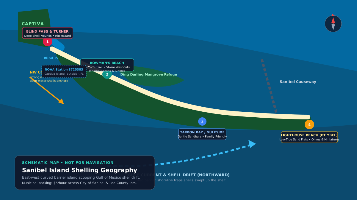
SCHEMATIC MAP • NOT FOR NAVIGATION
Sanibel Beaches Side-by-Side Comparison Matrix
Compare Sanibel's public beach parks across wave energy, parking logistics, walking distances, and typical shell deposits:
| Beach Park | Character & Wave Exposure | Target Shell Species | Walk from Parking | Parking Fees & Capacity | Facilities | Best Shelling Match |
|---|---|---|---|---|---|---|
| Bowman's Beach | Remote, undeveloped natural barrier dunes with high wave exposure High (open Gulf exposure, direct northwest swells) |
Lightning Whelks, Florida Fighting Conchs, Horse Conchs, Calico Scallops, post-storm Junonias | 0.25–0.35 mi (~5–8 min) nature trail across bayou footbridge | ~200+ spaces; $5.00/hr (City of Sanibel mobile app or kiosks) | Restrooms, change areas, outdoor showers, picnic grills, kayak launch | Beachcombers seeking uncrowded shores, exercise, and large heavy specimens |
| Blind Pass & Turner Beach | Dynamic tidal inlet between Sanibel & Captiva with massive shell gravel banks Extreme current in pass channel; high wave energy on outer Gulf beach |
Florida Fighting Conchs, Lion's Paws, Banded Tulips, Lettered Olives, Calico Scallops | Short walk (1–2 min) directly from parking stalls to beach | Sanibel side: ~29 spaces; Captiva side (Turner Beach): ~27 spaces; $5.00/hr (paid hourly permits transfer between Sanibel beach parks and Turner Beach while time remains) | Captiva side: Restrooms & shower; Sanibel side: Portable restrooms | Dedicated shellers targeting deep shell piles with scoops; thick footwear required |
| Sanibel Lighthouse Beach (Point Ybel) | Historic lighthouse point where Gulf meets San Carlos Bay; vast low-tide sand flats Moderate to calm; swift tidal current around the point |
Lettered Olives, Angulate Wentletraps, Coquinas, Shark Eyes, juvenile Fighting Conchs | Short walk (1–3 min) through maritime hammock to shoreline | Bayside & Gulfside lots (~150 spaces); $5.00/hr (City of Sanibel) | Restrooms, outdoor showers, shade pavilion, fishing pier | Sunrise shelling, families, miniature shell collectors, and wading sandbars |
| Tarpon Bay Road Beach / Gulfside City Park | Mid-island south-facing shore with gentle gradient and accessible access Gentle to moderate (protected south-facing shoreline) |
Sunray Venus Clams, Giant Atlantic Cockles, Sand Dollars, Banded Tulips | Very short walk (1 min) across short boardwalk over primary dune | Tarpon Bay: ~76 spaces; Gulfside (Algiers): ~46 spaces; $5.00/hr (City of Sanibel) | Restrooms, outdoor showers, bike racks, picnic tables | Families with small children, strollers, or shellers with limited mobility |
Which Sanibel Beach Should You Choose?
Use this decision guide to match your physical mobility, gear setup, and shell-hunting priorities:
Head to Bowman's Beach
Bowman's receives the full brunt of northwest winter swells. Walking 0.75 miles north toward Silver Key gets you past casual beachgoers onto untouched drift lines where large gastropods and heavy bivalves wash ashore.
Head to Blind Pass (Turner Beach)
The funneling currents of Blind Pass act as a hydraulic deposit machine, dumping millions of shells into gravel mounds 2 to 3 feet deep right at the waterline. Bring a long-handled wire scoop and sturdy water shoes.
Head to Sanibel Lighthouse Beach
Point Ybel faces southeast, catching the earliest sunrise light. At negative low tide, hundreds of yards of rippled sandbars emerge, exposing miniature wentletraps, burrowing lettered olives, and coquinas.
Head to Gulfside City Park (Algiers) or Tarpon Bay Beach
Unlike Bowman's Beach (which requires a 0.3-mile hike across a bayou bridge), mid-island access points have boardwalks that drop you onto the sand within 60 seconds of parking.
Seasonal Timing & Cold Front Dynamics
Winter Shelling (Dec–Apr): Winter (December through April) is Southwest Florida's premier shelling season. Strong cold fronts bring sustained 20–30 mph northwest winds that push deep shelf water toward the coast, followed by crisp morning negative low tides that reveal fresh deposits.
Summer Shelling (May–Sep): Summer (May through September) brings calm turquoise Gulf waters and afternoon thunderstorms. Morning low tides are excellent for wading sandbars, but afternoon lightning requires immediate departure from open beaches.
Daily Planning Rule: Arrive 45 to 60 minutes before the scheduled low tide. The falling tide reveals freshly uncovered shells before other beachcombers arrive.
Tides, Wind Dynamics & NOAA Station Predictions
Tidal Regime & NOAA Station Correlation: Astronomical predictions are sourced from NOAA CO-OPS Station 8725383 (Captiva Island (outside), FL). Station 8725383 is located in open Gulf of Mexico waters directly off Captiva and northern Sanibel. Because Sanibel's Gulf beaches face open water, predictions from Station 8725383 accurately represent open-beach high and low water times without the 30- to 60-minute lag that affects gauges inside Pine Island Sound or San Carlos Bay.
Wind & Wave Dynamics:
Predictions are computed astronomical heights. Local barometric pressure, wind setup, and wave surge will cause real-time water levels to deviate from predictions. Shell deposits are never guaranteed.
Florida Wildlife Law & Shelling Ethics
Strict Live Shelling Prohibitions (Lee County Ordinance 89-08 / 04-20)
Collecting any living seashell, sea star, sea urchin, or sand dollar is strictly illegal everywhere on Sanibel Island and throughout Lee County. If an animal is inside or attached, gently return it to the water where you found it. Violations carry substantial fines and potential misdemeanor citations.
Dune Protection: Coastal dunes and sea oats are vital storm buffers protected under Florida statute. Never walk on dunes or pick sea oats; use marked boardwalks and public trails only.
Official Verification & Authoritative Sources
Primary Authoritative References
- City of Sanibel Parks & Recreation: Official Sanibel beach park municipal information, hourly parking rates ($5/hr), facilities, and park rules.
- Lee County Code of Ordinances Chapter 14: Ordinance 89-08 / 04-20: Marine Mollusk & Live Shelling Regulations for Lee County, FL.
- NOAA CO-OPS Station 8725383: Captiva Island (outside), FL open Gulf water astronomical tide predictions.
- Sanibel-Captiva Conservation Foundation (SCCF): Coastal morphology, dune ecology, shorebird and sea turtle conservation guidelines.
Prized Shell Species on Sanibel Island
Learn how to identify and ethically collect the most sought-after specimens found along Sanibel's shores:
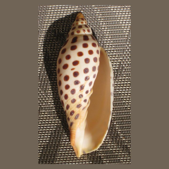 JunoniaScaphella junonia
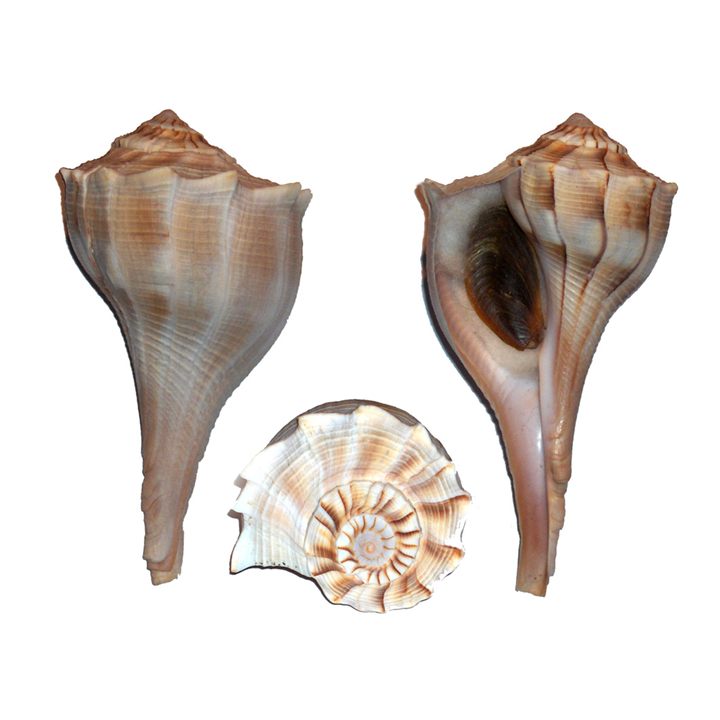 Lightning WhelkSinistrofulgur perversum
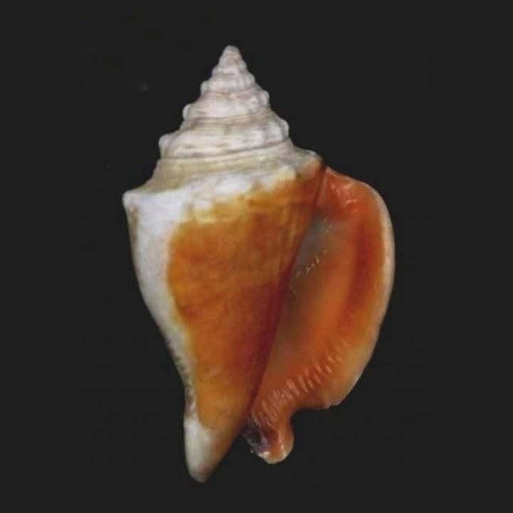 Florida Fighting ConchStrombus alatus
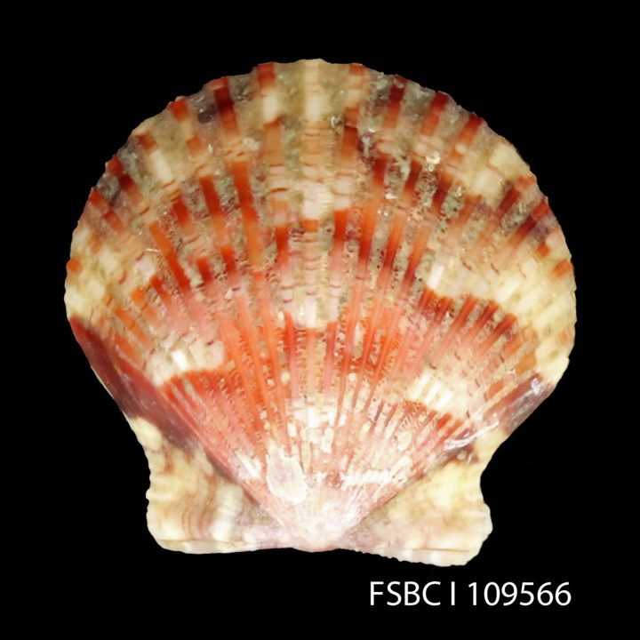 Calico ScallopArgopecten gibbus
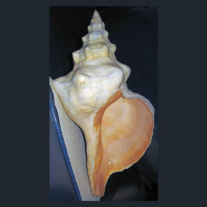 Florida Horse ConchTriplofusus giganteus
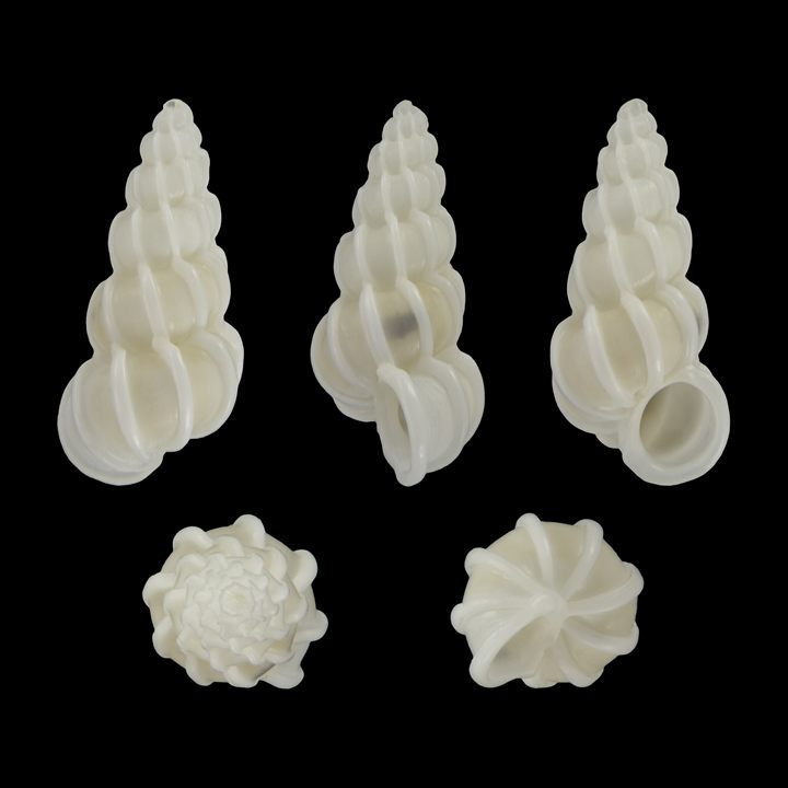 Angulate WentletrapEpitonium angulatum
Browse all 24 Southwest Florida shell identification guides →