Bowman's Beach Shelling Guide
Complete field guide to shelling Bowman's Beach on Sanibel: nature trail distance, $5/hr parking kiosks, facilities, wave exposure, best tides, and how to find large whelks and Junonias.
Bowman's Beach is Sanibel's premier undeveloped municipal beach, renowned for wide natural sand dunes, high wave exposure, and productive post-storm shell deposits. Access requires a 5–8 minute (0.25–0.35 mi) walk across a scenic wooden footbridge over Clam Bayou.
Bowman's Beach Field Map & Shell Drift Zones
Field Orientation: Orientation map showing the 1700 Bowman's Beach Road parking lot, the 0.25-mile nature trail across the Clam Bayou footbridge, and the wide Gulf drift zones. Schematic map only • strictly not for land or marine navigation.
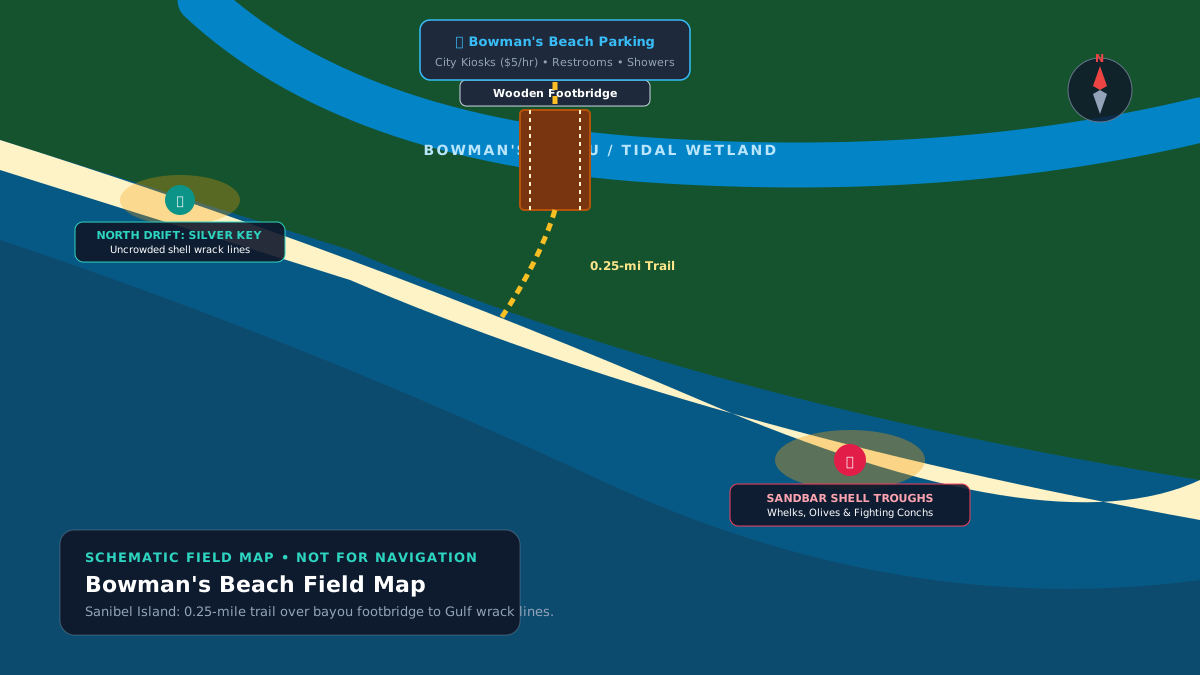
SCHEMATIC MAP • NOT FOR NAVIGATION
Shelling Strategy & Realistic Expectations
Coastal Exposure & Beach Morphology: Bowman's Beach features a west / northwest facing open gulf of mexico. Wide undeveloped barrier beach backed by vegetated dunes; strong longshore bars and seasonal storm washouts.
The Three Drift Zones: Examine three distinct tiers along the slope: (1) Upper dry wrack line for sun-bleached bivalves, egg cases, and sand dollars; (2) Mid-slope damp shell trough where waves tumble rolling whelks and conchs; and (3) Active low-tide swash zone where water drop reveals freshly uncovered shells.
Escaping the Crowds: Most casual visitors stop immediately at the end of the main trail. Walk at least 0.5 to 1.5 miles northwest toward Silver Key or southeast toward Blind Pass to escape the crowds and find pristine, unpicked wrack lines.
Primary Target Species at Bowman's Beach
- Lightning Whelk (Sinistrofulgur perversum): Prized large gastropod found in shallow offshore drop-offs
- Florida Fighting Conch (Strombus alatus): Very common along active low-tide swash lines
- Calico Scallop (Argopecten gibbus): Abundant in dense mid-beach shell piles
- Atlantic Giant Cockle (Dinocardium robustum): Heavy paired valves washed onto upper beach
- Junonia (Scaphella junonia): Rare post-storm wash-in rolled from deep shelf beds
Realistic Expectation: Shell wash-ins depend on wave action and tide timing. While Bowman's produces legendary finds following winter cold fronts, quiet calm summer days often feature scattered common bivalves. We never fabricate visit reports or guarantee specific finds.
Location, Trail Access & Verified Parking Details
Address: 1700 Bowman's Beach Rd, Sanibel, FL 33957 • Jurisdiction: City of Sanibel Parks & Recreation
Parking Logistics & Hourly Fees
Parking Spaces: ~200+ vehicle stalls
Hourly Fee: $5.00 per hour (via mobile app or on-site credit card pay kiosks)
Managed by the City of Sanibel. Cash is not accepted at kiosks; pay using major credit cards or designated mobile parking apps. Paid hourly beach parking receipts are transferable between all City of Sanibel public beach park lots (including Turner Beach Park on Captiva) for unexpired time. The lot fills early between 9:30 AM and 1:00 PM during peak winter months (December through April). Verify current rates and rules with the City of Sanibel.
The Nature Trail Walk (~0.25 to 0.35 Mile)
0.25 to 0.35 miles (~5 to 8 minutes) along a packed gravel and sand trail, crossing an elevated wooden footbridge over Clam Bayou before traversing the coastal dune system to reach the Gulf. A beach wagon with wide balloon tires or a backpack carrier is strongly advised for heavy gear, coolers, or young children.
On-Site Park Amenities
- Restrooms with running water, flush toilets, and changing stalls
- Outdoor freshwater foot-wash stations and rinse-off showers
- Shaded picnic pavilions and charcoal barbecue grills
- Canoe and kayak launch dock on Clam Bayou
- Bicycle parking racks at the trail-head
- No equipment rentals, beach chairs, or food concessions on site (bring your own water and supplies)
Tides, Wind Dynamics & NOAA Station Predictions
Tidal Regime & NOAA Station Correlation: Astronomical predictions are sourced from NOAA CO-OPS Station 8725383 (Captiva Island (outside), FL). Station 8725383 is located in the open Gulf approximately 4 miles northwest of Bowman's Beach. Because Bowman's faces the open Gulf directly, this outer station provides accurate tidal timing, avoiding the 30- to 60-minute delays of inland bay gauges.
Wind & Wave Dynamics: Strong northwest winds (20+ mph) associated with winter cold fronts push Gulf swells onshore, driving deep-water shells onto the beach. When the wind shifts northeast or drops to calm at sunrise low tide, conditions are optimal.
Predictions are calculated astronomical tide heights relative to Mean Lower Low Water (MLLW). Real-time water levels are influenced by wind direction, atmospheric pressure, and surf conditions. Predictions never guarantee shell deposits or beach safety.
Beach Hazards, Safety & Sanibel Regulations
Safety Hazards & Open Shoreline Caution
- No municipal lifeguards are stationed at Bowman's Beach; swim, wade, and shell at your own risk.
- Moderate to heavy surf during winter cold fronts; heed all beach condition flags.
- Stingrays frequent shallow sandy troughs during warmer months; do the 'stingray shuffle' when wading.
- Alligators occasionally inhabit Clam Bayou; do not wade or swim in the bayou waters.
City of Sanibel & Lee County Beach Regulations
- Lee County Ordinance 89-08 / 04-20 & City of Sanibel Code: Strict 100% ban on collecting living mollusks, sea urchins, sand dollars, and starfish. Inspect every shell before keeping.
- Dogs allowed on leash (maximum 8 feet) at all times; handlers must collect and dispose of pet waste.
- Do not walk on coastal sand dunes or disturb sea oats, which are legally protected erosion barriers.
- Shorebird and sea turtle nesting zones: Do not approach marked nesting enclosures (May–October turtle nesting; year-round plovers and terns).
Official Verification & Authoritative Sources
Primary Authoritative References
- City of Sanibel Parks & Recreation: Official municipal geographic data for Bowman's Beach (1700 Bowman's Beach Rd), parking kiosk rates ($5/hr), and park rules.
- Lee County Code of Ordinances Chapter 14: Ordinance 89-08 / 04-20: Marine Mollusk & Live Shelling Regulations for Lee County, FL.
- NOAA CO-OPS Station 8725383: Captiva Island (outside), FL open Gulf water astronomical tide predictions.